Good day my good friend.
A housekeeping announcement, this. I will be taking some time off next week, mainly to deal with a few family matters. So there will be no newsletter for that time, I am afraid to say. So make the most of this week while you can.
If you like this newsletter, please share it with someone else who you think will love it. The main way my audience grows is through your recommendations. I will love you forever if you do. 😍
⏩ The impact of design speed
One of the biggest challenges facing Wales’ national 20mph speed limit is not the fact of whether it will reduce traffic speeds (it is), but it is of the scale of that change. Throughout its development and delivery, one of the consistent challenges against the idea is a simple one. Namely that many roads in places across Wales are not designed for 20mph. And therefore achieving 20mph consistently requires physical intervention.
This is not just about putting physical objects in a road that is otherwise designed with big sightlines and straight lines. It is about a built environment that snuggles up to the highway, creating bends and safe sightline blockages that slow people down, just a fraction, through clever design.
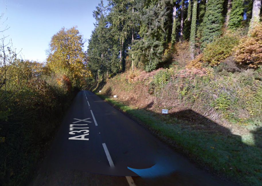
Believe it or not, the same can be achieved on rural roads. Many of you may have driven along rural roads that hug the landscape. Where the road bends, dips, and rises as it hugs the hillside, or trees growing over to create a tunnel effect. And the impacts on driving speed of this can be quite profound.
I will use an example of a road that I know all too well to showcase this. Namely the roads between Barnstaple and Exeter in Devon. Naturally, I expect most of you would choose the Tarka Line over driving between these places, but bear with me on this.
Driving between the two, you have two options, referred to by the locals as “The Old Road” and “The Link Road.” The former meanders along the valley of the Rivers Taw and Exe past Umberleigh, Lapford, Eggesford, through Crediton and into Exeter from the North West. The latter involves driving down the A361 North Devon Link Road, getting on the M5 near Tiverton Parkway station, and heading south and into Exeter from the East.
When you look at the two options on Google Maps, you will notice something. While The Link Road is fully twelve miles further (and over 25% further) than The Old Road, it takes just one minute longer to drive.
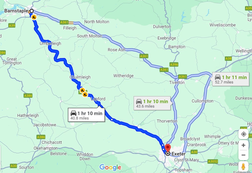
The drive from Barnstaple to Exeter (Source: Google Maps)
Looking at Streetview, you get a very clear idea as to why. The Old Road lives up to its name. Despite being an A-road, it is twisty, turny, and often narrow in places – not to mention having to drive through the centre of villages and across narrow bridges. For decades, however, this was the only realistic way to drive from Barnstaple to Exeter.


Contrast this with the Link Road. As well as being connected to a motorway, the route between the M5 and Barnstaple – built on an old railway line in the 1980s – has been built for higher speeds. Despite you often having to crawl behind lorries or caravans on some of the steeper hills. This is a route built for speed.


The net result of this is a rather strange impact on choices. The Old Road, which is a shorter distance and theoretically would emit lower emissions on the journey, can be out-competed by The Link Road, all because The Link Road was designed to a higher speed.
Speaking to my own family, often their choice of route comes down to what side of Exeter their destination is on. My nephew, for example, lives in Barnstaple and drives to Exeter regularly. Going to work in the city centre (more towards the western side of the city) and he chooses The Old Road. But whenever he wants to go to watch Exeter Chiefs at Sandy Park (on the eastern side of the city), he chooses The Link Road.
We know of such trade-offs, of course. This is partly why we model the impact of schemes before they are delivered – to understand these potential trade-offs better. But this shows the power of the design choices that we make, and their ability to influence how we travel. Maybe we should start designing for more twists and turns, even on routes and schemes where this is not intended.
What you can do: This is a simple thing. When campaigning to reduce traffic speeds in your area, while a speed limit is good, campaign to reduce the design speed of the road. Work with councillors and council officers to run workshops with the community to explore low cost solutions to achieving this. And then campaign to get the funding to deliver it. And if you are a scheme designer or promoter, use Manual for Streets, not DMRB, to help design your road.
👩✈️ From academia
The clever clogs at our universities have published the following excellent research. Where you are unable to access the research, email the author – they may give you a copy of the research paper for free.
Impact of Speed Limit Enforcement Cameras on Speed Behavior: Naturalistic Evidence from Brazil
TL:DR – The impact of speed cameras on reducing traffic speeds depends on site conditions.
Understanding train tourism mobilities: a practice theories perspective
TL:DR – Really small changes can affect using the train for tourist purposes.
Is proximity enough? A critical analysis of a 15-minute city considering individual perceptions
TL:DR – The preferences of services to be included in 15 minute cities varies far more than we think it does.
TL:DR – Autonomous vehicles could radically change how park and ride systems operate.
✊ Amazing people doing amazing things
I’m not usually a person who favours a tech solution for what should be an infrastructure fix. But at the same time, what we need to realise is that people with mobility issues may have different needs and different preferences. That is why I quite like what Portsmouth City Council are doing. As well as upgrading pedestrian crossings so they are more accessible to those in wheelchairs, they have linked them with a smartphone app that acts in a similar way to existing systems that help them switch the lights to green. Let’s see how it goes.
📺 On the (You)Tube
Sometimes you just need a video with some maps to show the scale of parking that is provided in many cities. Or you use Parkulator.
🖼 Graphic Design

The effects of Uber and Lyft on the New York Taxi Market (Source: r/dataisbeautiful)
Now this is how you break and establish a monopoly. Uber and Lyft have crushed New York Taxis over time.
📚 Random Things
These links are meant to make you think about the things that affect our world in transport, and not just think about transport itself. I hope that you enjoy them.
- Delta Eclipse Flight: How to See the Rare Event at 30,000 Feet (Business Traveller)
- Leasing Like a State, or: Public Housing is Development Policy (Global Developments)
- Geologists signal start of hydrogen energy ‘gold rush’ (Financial Times)
- Disinformation threatens global elections – here’s how to fight back (The Conversation)
- The wealth of generations (VoxEU)
📰 The bottom of the news
There is a direct train service between Barking in East London and China, believe it or not. Ok, you may not like the seating arrangements, and you’d have to travel through some dictatorships to get there. What’s more, Barking wants to see more services to more countries of the world.
👍 Your feedback is essential
I want to make the calls to actions better. To do this, I need your feedback. Just fill in the 3 question survey form by clicking on the below button to provide me with quick feedback, that I can put into action. Thank you so much.